The man who turned the Portuguese enterprise from a string of coastal trading posts into an imperial design came to the throne in the last week of August 1481. He was twenty-six years old, tall, finely muscled, with a face that gave nothing away. His eyes, wrote the chronicler Rui de Pina, were "black and penetrating, and he looked at men in such a way that they understood he was reading their thoughts before they had spoken them." His name was João, the second of that name, and within three years of his accession he would personally drive a knife into the heart of his brother-in-law and hold the blade steady while the man bled out at his feet.
This was not cruelty. It was policy.
João II inherited a kingdom that had lost its way. Prince Henry was two decades dead. The African trade, such as it was, had fallen into the hands of private contractors, Genoese financiers, and a gaggle of noble families who saw the Guinea coast as their personal fiefdom. The crown received its fifth, but the fifth was a trickle. The maps were scattered. The strategic vision was nonexistent. Portugal was drifting, and João understood drift as a form of death.
Within months of taking the throne, he summoned the great nobles to Évora and demanded a new oath of fealty — an oath that required them to place their hands upon a Bible and swear obedience not just to the king but to the state, and to surrender all lands and titles for royal confirmation. The nobility understood the implications immediately. This was not medieval kingship. This was something new, something Roman, something absolute.
The Knife in the Chamber#
The Duke of Braganza, the richest landowner in the kingdom, refused. He wrote letters to the court of Castile, feeling for allies, testing the waters of rebellion. João's spies intercepted the correspondence. The duke was arrested, tried in a courtroom draped in black cloth, convicted by a panel of judges that included the king himself, and executed in the main square of Évora on the twenty-second of June 1483. The chroniclers noted the heat that day, the dust kicked up by the horses, the way the duke's supporters wept openly while the king watched from a window, his face unmoving.
The following year, his own brother-in-law, the Duke of Viseu, plotted to kill him. João summoned the young man to his private chambers in the palace at Setúbal. The room was small, hung with maps. The king closed the door, produced a dagger, and stabbed the duke in the chest. He held him there, the blade still in the wound, until the man stopped breathing. Then he cleaned the weapon, called for his guards, and informed the court that the succession crisis was over.
After that, no one questioned the king's authority. The Portuguese expansion was no longer a family business. It was a state project, directed by a single will, and that will was implacable.
The Scientific State#
With the court subdued, João turned to the sea. His first act was to build. On a rocky headland on the Gold Coast, at a place the Africans called Elmina — the mine — he ordered the construction of a fortress. São Jorge da Mina rose in 1482, a quadrangle of whitewashed stone with towers at each corner and a garrison of sixty men. It was the first permanent European stronghold in the tropics, and it was placed directly at the source of the gold. The caravans that had once crossed the Sahara to Ceuta now came to Mina. The Portuguese loaded their ships with brass bracelets, cotton cloth, glass beads, and sailed home with holds full of gold dust. By the end of João's reign, Mina was delivering half a ton of gold a year to the Lisbon treasury.
But the fortress was only the beginning. João wanted more than gold. He wanted the Indian Ocean.
The problem was scientific. For centuries, European ships had sailed by dead reckoning: a pilot estimated his speed by watching the water pass the hull, his direction by compass, and hoped. On the open Atlantic, away from landmarks, the method was lethal. The Portuguese had learned to swing wide into the ocean — the volta do mar — to catch the westerlies that would carry them home, but this was intuition, not navigation. No one knew how to measure latitude south of the equator, where the Pole Star disappeared below the horizon.
João set out to solve this. He gathered a committee, the Junta dos Matemáticos, composed of astronomers, cartographers, and mathematicians — Christians and Jews, Portuguese and foreign. Among them was Abraham Zacuto, a Jewish scholar from Salamanca who had fled the Spanish Inquisition and carried with him the astronomical tables that would revolutionize maritime navigation. Zacuto and his pupils adapted the astrolabe for use on a rolling deck. They produced the Regimento do Astrolábio, the first European navigational manual, a slim volume of declination tables and instructions that allowed a pilot to measure the altitude of the sun at noon and convert that angle into a latitude line. For the first time, a ship lost on the ocean could know exactly where it was in relation to the equator. The sea, which had always been a space of mystery and terror, was becoming a grid.
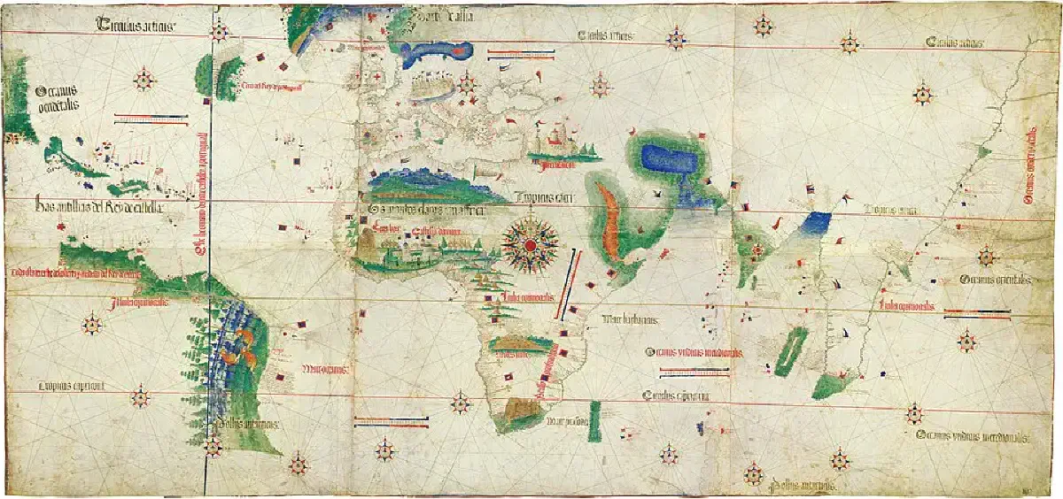
The king had maps drawn, and he kept them secret. He sent spies to the ports of the Mediterranean, to Venice, to Cairo, to Sofala, to report on the spice trade, the monsoon patterns, the location of Prester John's kingdom. The crown's cartographers worked behind locked doors in the Palace of Alcáçova, compiling a master chart of the known world, adding each new cape and river as the caravels returned. These were state secrets. The penalty for leaking a chart was death. João was not exploring the world. He was building a monopoly.
The Pillars of Cao#
In 1482, he launched the next thrust south. The captain he chose was Diogo Cão, a man about whom almost nothing is known — no birth date, no lineage, no portrait — except that he was trusted by the king. Cão commanded two caravels. His mission was to push beyond the equator and leave a permanent mark.
He carried with him the first padrões — stone pillars six feet high, carved from Lisbon limestone, surmounted by an iron cross and engraved with the royal coat of arms. They were designed to be planted on any new coast the Portuguese claimed. They were assertions of sovereignty carved in stone, and they were heavier than cannon. Cão had to haul them over the side by hand and drag them up the beaches of a continent that had never seen a European.
At the mouth of an enormous river — five miles wide at its estuary, brown with silt — he erected his first pillar in August 1483. The river was the Congo. The people there were the Kongo, a sophisticated kingdom with a king, the Manikongo, who ruled from a wooden palace in the interior. Cão sent emissaries upstream, exchanged gifts, and took four Kongo hostages back to Lisbon with a promise to return them. The hostages became a sensation. They learned Portuguese, converted to Christianity, and were treated as honoured guests. João intended to establish a Christian alliance with the Kongo kingdom, a back door to Prester John. The river, he hoped, led east.
Cão's second voyage, in 1485, carried the hostages back home and pushed further south. He planted a pillar at Cape Santa Maria, another at Cape Negro, and finally a fourth at a place in present-day Namibia, at 22° south latitude. He called it Cape Cross. The pillar still stands there, the oldest European monument in southern Africa, its cross eaten by the salt wind, its inscription barely legible. Cão went further, perhaps to Walvis Bay, and then vanished. No trace of his ships or his body was ever found. He had reached the edge of the map and been consumed by it.
The loss of Cão was a setback, but João was already preparing the next expedition. The master plan was now clear: find the southern tip of Africa, round it, and enter the Indian Ocean. To do this, the king launched two simultaneous missions in 1487 — one by sea, one by land.
The land mission was pure audacity. João selected Pêro da Covilhã, a wiry, multilingual squire who spoke Arabic and Castilian fluently, and Afonso de Paiva, a gentleman of the royal household. Their orders were to travel to the Indian Ocean, find the source of the spice trade, and locate the kingdom of Prester John. They were given a letter of credit drawn on Florentine banking houses, a set of maps, and no protection beyond their wits.
Covilhã and Paiva departed Lisbon on the seventh of May 1487, rode through Spain to Barcelona, took ship to Naples, and then crossed to Rhodes and Alexandria disguised as honey merchants. They joined a camel caravan to Cairo, survived a sandstorm in the Sinai, sailed down the Red Sea to Aden, and separated. Paiva headed south to Ethiopia, the rumoured seat of Prester John. He would die somewhere in the Abyssinian highlands, his fate unknown for decades. Covilhã caught a dhow across the Indian Ocean to Calicut, the pepper capital of the Malabar Coast. He wandered the spice markets, noting the prices, the shipping routes, the monsoon schedules. "Whoever holds Malacca has his hand on the throat of Venice," he later reported. He sailed north to Goa and Hormuz, then down the African coast to Sofala, the Arab gold port opposite Madagascar. From there, he wrote a letter to King João, detailing the entire geography of the Indian Ocean trade. The letter reached Lisbon. Covilhã himself pushed on to Ethiopia, where the emperor, the supposed Prester John, welcomed him warmly and then refused to let him leave. He would live out the rest of his life in the mountains, a prisoner of honour, a living piece of intelligence that could not send another message. But the letter had been enough. It confirmed what João already suspected: the sea route around Africa existed, and the Indian Ocean was open.
Rounding the Cape#
The sea mission was the one that would alter the map. In August 1487, as Covilhã was crossing the Sinai, three ships cleared the Tagus bar under the command of Bartolomeu Dias. He was a gentleman of the royal household, an experienced navigator of the Guinea coast, and he carried with him two armed caravels — the São Cristóvão and the São Pantaleão — and a smaller supply ship, a square-rigged store vessel that could be broken up for firewood when it was empty. Also aboard were six Africans, taken from their homes on previous voyages, now dressed in Portuguese clothes and carrying samples of gold, silver, and spices. Their task was to be landed at promising spots along the coast, to make contact with local rulers and explain the virtues of trade with Portugal. They were walking advertisements, human cargo of the empire to come.
The fleet sailed south along the familiar African coast, past the pillars of Diogo Cão, past Cape Cross, into the latitudes where the Atlantic turns cold and the winds shift. At Walvis Bay, Dias unloaded the supply ship and left it with a nine-man caretaker crew. He would pick them up on the return voyage. Then he turned his bows southwest, into the open ocean.
What happened next became legend. Off the coast of present-day Namibia, a storm hit. It was not a squall. It was a southern ocean gale of the kind that builds over thousands of miles of uninterrupted water, the wind screaming from the west, the waves towering like black mountains. The chronicler João de Barros wrote: "He ran before it for thirteen days, seeing no land and expecting each moment to be his last." Dias ordered all sails struck except the foresail. The caravels were driven south, far south, into the latitudes of ice and albatross. The men huddled below decks. The Africans, never having experienced such cold, shivered uncontrollably. The ships leaked. The pumps clattered day and night. Dias held the course.
When the storm relented, he turned east, expecting to find the African coast. He found only open ocean. He sailed east for days, then days more. The sea was empty. He realized what had happened. The storm had carried him around the tip of the continent without his knowing. He had done it. He ordered the ships to turn north.
On the third of February 1488, they sighted land. But the coastline was running east-west, not north-south. The sun was now at their right, not their left. They had crossed into the Indian Ocean. Dias anchored in a broad bay where cattle grazed on the green hills, and he named it the Aguada de São Brás — the Watering Place of Saint Blaise. The local herders, the Khoikhoi, watched from a distance and kept their cattle away. One of the Africans aboard the ships tried to make contact, but the Khoikhoi pelted him with stones. Dias shot one dead with a crossbow. It was the first European blood shed on the coast of what would become South Africa.
The fleet pushed east along the shore. At a river mouth Dias named the Rio do Infante — after his co-captain, João Infante — he planted his final stone pillar, at a place now called Kwaaihoek. The coast was bending steadily northeast. Ahead lay the Zulu kingdoms, the Swahili city-states, the monsoon ports of Arabia and India. The sea road was open.
But the crew had had enough. The biscuit was running low. The water casks were foul. The supply ship was somewhere far to the west. The men mutinied, refusing to go further. Dias consulted his officers, then agreed to turn back. Before he did, he went ashore, knelt in the sand, and wept. The chronicle says he bid farewell to the pillar "with as much sorrow as if he were leaving a son condemned to exile." He was within weeks of India and could not reach it.
On the return voyage, in May 1488, they sighted the great cape for the first time. It rose from the sea like a fortress wall, a massif of grey granite and green vegetation, its summit wreathed in cloud, the surf exploding against its foot in curtains of white spray. Dias named it the Cape of Storms. When he returned to Lisbon in December 1488 — after retrieving the supply ship's caretaker crew, of whom only three were still alive, the others having been killed by disease and loneliness — King João received him with public honour and private calculation. The cape was a landmark of immense power. It needed a better name. João renamed it the Cape of Good Hope, because, as Barros recorded, "it gave promise of the discovery of India, so long desired and sought for over so many years."
Columbus, Tordesillas, and the Race#
The report of Dias's return sent a tremor through the court of Portugal and beyond it. In the spring of 1493, a Genoese sailor living in Lisbon named Christopher Columbus returned from a voyage to the west under the flag of Castile, claiming to have reached the Indies by crossing the Atlantic. João received him coldly. Columbus had approached him first, in 1484, pitching his scheme to sail west to Cathay. João had referred the proposal to his Junta dos Matemáticos. The mathematicians, armed with Zacuto's tables and their own calculations of the earth's circumference, had judged Columbus's estimates wildly optimistic — the distance was far greater than he claimed. They had advised the king to refuse. Now Columbus stood before him, fresh from his discovery of scattered islands in the Caribbean, crowing about his success. João listened, and then informed him that, under the Treaty of Alcáçovas of 1479, the lands Columbus had found lay within the Portuguese sphere of influence. He threatened to send a fleet to take possession. The matter was resolved by papal mediation and the Treaty of Tordesillas in 1494, which drew a line down the Atlantic and gave Brazil — still unknown — to Portugal. But João understood the deeper truth: Castile had entered the race. The clock was ticking.
He accelerated his preparations for the India voyage. Shipwrights laid down keels for vessels stronger than caravels, capable of carrying heavy cannon and withstanding the storms of the southern ocean. Supplies were stockpiled. Commanders were vetted. The expedition was to be led by a man named Estevão da Gama, a trusted officer of the royal household.
But the expedition did not sail under João II. In the summer of 1495, the king fell ill. The symptoms were consistent with uremic poisoning, perhaps from a kidney disease, perhaps from the long-term use of an arsenic-based tonic he had taken since his youth. He died on the twenty-fifth of October, at the age of forty, in the castle at Alvor, on a cliff overlooking the sea he had spent his life charting. His only legitimate son, Prince Afonso, had died in a riding accident four years earlier — a tragedy that had broken the king's spirit, according to those who knew him. The throne passed to his cousin Manuel, a twenty-six-year-old duke with no experience of statecraft but a fervent, almost mystical belief in Portugal's divine mission.
The grand design was complete. The Atlantic was mapped. The southern route was open. The Indian Ocean had been reconnoitred. The ships were ready. All that remained was to launch them.
Manuel would be the one to push the button. But the machine had been built by the Perfect Prince.