This is not a matter of cultural superiority, national character, or even technological genius, although all of those play their parts. It is a brute fact of geography. The ocean is the great superhighway of global trade and military power, and a state that lacks direct, unblocked access to it is not merely disadvantaged—it is structurally excluded from the highest tier of global dominance. The tragic fate of the Ottoman Empire and the staggering success of the United States of America are, above all, geographical stories. One was a prisoner of a sea; the other is the master of two oceans.
The Initial and Boundary Conditions of History#
To understand the fate of empires, we must first understand the terrain. Geography provides the initial condition: where a people settles determines the crops they can grow, the rivers they can navigate, the natural harbors they can develop, and the neighbors they must fight. A civilization born on a fertile river delta, protected by deserts and connected to inland seas, will evolve differently from one perched on the edge of a storm-wracked ocean, staring into an infinite horizon.
But geography also provides the boundary condition. It sets the hard, non-negotiable limits of what even the most brilliant and ruthless state can achieve. A landlocked empire in Central Asia, no matter how vast its cavalry armies, can never become a naval power. A kingdom hemmed in by impassable mountains can never command a global trade route. Ambition and political will can push against these limits, sometimes for centuries, but the walls will hold. In the long run, geography defines the ceiling of power.
The story of the last half-millennium is the story of the Atlantic Ocean shattering those old boundaries for a few lucky states on its rim—and of other, equally powerful empires, trapped by their own geography, slowly suffocating as the world moved on without them.
The Ocean as Superhighway: Why Seas Are Not Enough#
A critical distinction must be made here, one that the Ottomans learned to their eternal cost: the difference between a sea and an ocean.
A sea like the Mediterranean is a magnificent body of water, but it is a closed basin. It is a cul-de-sac. Its winds are fickle, its tides negligible, its only exit a narrow, easily blockaded chokepoint. For millennia, the Mediterranean was the center of the world, and the empires that commanded it—Rome, Byzantium, the Italian maritime republics—were the apex powers of their age. But the Mediterranean is a highway for regional, not global, trade. It connects three continents, but it does not reach the vast planetary ocean that, after 1492, became the true arena of wealth and power.
An ocean, by contrast, is a superhighway without gates. The Atlantic, the Pacific, and the Indian Ocean connect the entire globe. A state with direct, unblocked access to an ocean can project its power across the planet. It can trade directly with distant continents, bypassing middlemen, and it can transport armies and settlers to seize and hold territory thousands of miles from its home shores. Crucially, an oceanic empire does not need to ask permission to pass through a rival's strait or to pay tolls to a hostile power. The open ocean is the ultimate commons, and those who can build ships that master it can write the rules of the global order.
This is why the Ottoman Empire, for all its three-continent landmass, was doomed the moment Vasco da Gama rounded the Cape of Good Hope. The Ottomans had the Mediterranean. They did not have an ocean.
The Ottoman Trap: Mastery of a Sea, Imprisonment on a Planet#
The Ottoman Empire was, in many ways, the most impressive land empire of the early modern age. At its height, it stretched from the gates of Vienna to the Persian Gulf, from the Crimea to the sands of the Sahara. It commanded the eastern Mediterranean, the Black Sea, and the Red Sea. It was the indispensable middleman of world trade, sitting astride the Silk Road and the spice routes. To any observer in 1500, the Ottomans were a superpower.
But their geography was a cage, and they did not yet know it. The empire's maritime power was entirely confined to seas—the Mediterranean and the Red Sea—and both were locked.
To the west, the Strait of Gibraltar was the sole exit from the Mediterranean into the Atlantic. At just eight miles wide, this chokepoint was controlled by the Spanish Empire, an implacable enemy, and later by the British. An Ottoman fleet attempting to force its way through would have to run a gauntlet of shore batteries and waiting warships, after a 2,000-mile voyage from Istanbul with no friendly ports for resupply. The Ottoman navy, built around the oar-powered galley—a lethal weapon in a calm sea but a coffin on the open ocean—could never seriously contemplate an Atlantic breakout. The door to the west was slammed shut, and it would never open.
To the east, the empire faced the Red Sea Paradox. After conquering Egypt in 1517, the Ottomans gained access to the Red Sea and, through the Bab el-Mandeb strait, to the Indian Ocean. They built a shipyard at Suez and launched a brilliant century-long campaign against the Portuguese, raiding the Indian coast, aiding Muslim sultanates in Indonesia, and protecting the spice trade. But they could never win a decisive victory, and they could never become a true oceanic power, because Suez was a shipyard in a desert. Every plank of timber, every iron nail, every cannon had to be hauled over a hundred miles of scorching sand. Building Atlantic-style galleons—deep-hulled, broadside-firing, ocean-voyaging fortresses—was a logistical impossibility. The Ottomans could only build galleys, perfect for coastal raiding but helpless in the open Indian Ocean. And the Bab el-Mandeb was just as blockadable as Gibraltar. The Portuguese controlled its approaches, and the Ottomans could never freely sortie into the vast blue water beyond.
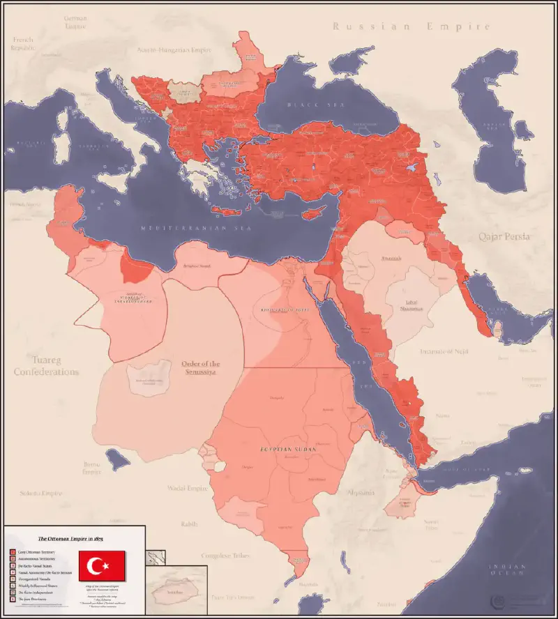
The result was a slow, terminal asphyxiation. While Spain and Portugal, and then the Netherlands, England, and France, poured into the Atlantic and Indian Oceans, seizing the Americas, establishing global colonial empires, and funneling unimaginable wealth into their treasuries, the Ottomans were left standing on the shore of a closed sea. The American silver that flooded Europe caused inflation that wrecked the Ottoman currency. The direct oceanic trade routes bypassed Ottoman markets, impoverishing the merchants of Aleppo and Alexandria. The Industrial Revolution, funded by Atlantic wealth, passed the empire by. By the 19th century, the Ottoman state was the "Sick Man of Europe," and it was finally dismembered by the British and French—two powers whose entire global dominance was built on the oceans the Ottomans could never reach.
The Ottomans could navigate the Mediterranean brilliantly. They were masters of the sea. But they could not navigate the oceans, and in the end, they lost even the land. The sea had become a trap.
The Atlantic Rim: Small Powers, Oceanic Empires#
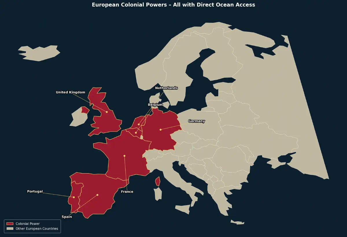
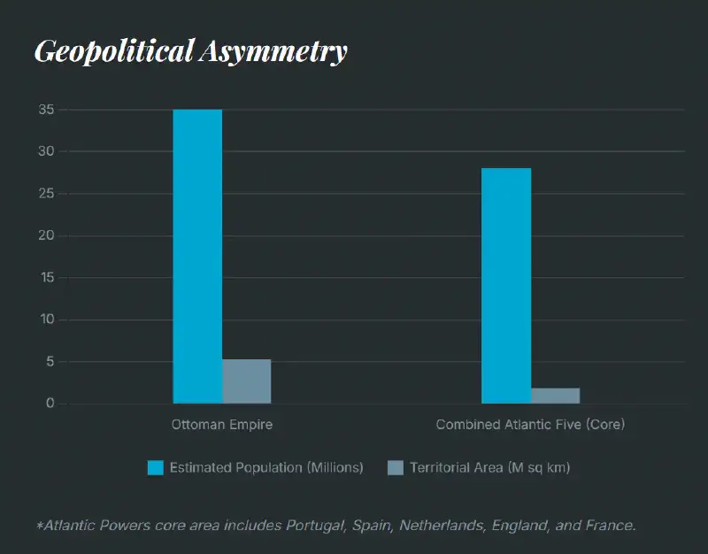
Perhaps the most devastating illustration of the oceanic imperative is the sheer asymmetry of size and power between the Ottoman Empire and the European colonial states that ultimately dismantled it. At its peak in the late 17th century, the Ottoman Empire held sway over roughly 5.2 million square kilometers of territory, from Central Europe to the Arabian Peninsula and North Africa, with a population estimated between 25 and 35 million. The combined land area and population of the five major Atlantic colonial powers—Portugal, Spain, the Netherlands, England (later Britain), and France—were, remarkably, less than that of the Ottoman Empire alone. Yet these small European states did not just surpass the Ottomans; they divided the globe among themselves, while the empire that once terrified Christendom was reduced to a supplicant.
How was this possible? The answer is written in the Atlantic Ocean. Each of these powers possessed a front door that opened directly onto the great highway of the modern world. They needed no permission to pass. They controlled their own chokepoints or had none at all. Their small size, far from being a weakness, became a competitive spur to maritime innovation, while the vast Ottoman landmass bred a conservative, army-centric mindset. The following brief survey reveals the geographic foundations of their triumph.
Portugal is the purest example. A tiny kingdom of barely 90,000 square kilometers, perched on the southwestern edge of Iberia, with a population of scarcely a million in 1500. Yet its entire coastline faced the open Atlantic, and it possessed no Mediterranean distractions. From Lisbon, Portuguese caravels sailed south around Africa and east into the Indian Ocean without any hostile chokepoint. They established a string of fortified trading posts from Mozambique to Macau, controlling the oceanic spice route that had once been an Ottoman overland monopoly. A nation smaller than the Ottoman province of Egypt became the first global maritime empire, all because its geography was purely Atlantic.
Spain was larger but still a fraction of the Ottoman landmass. It faced both the Mediterranean and the Atlantic, but its power projection came from its Atlantic ports—Seville, Cádiz, and later Lisbon after the union of crowns. From these harbors, Spain sent conquistadors and treasure fleets across an ocean that was open and unblockaded. The silver of Potosí and the gold of Mexico flowed directly into Spanish coffers, financing armies and fleets that fought the Ottomans in the Mediterranean itself. Spain’s Mediterranean coast was a side theater; its Atlantic coast was the engine of empire. Without the Gibraltar choke point to bar them, the Spanish could treat the ocean as their own.
The Netherlands was smaller still—a swampy, low-lying republic with a population of barely two million in the 17th century, a fraction of the Ottoman Balkans. But its entire existence was maritime. Facing the North Sea with a vast network of ports and inland waterways, the Dutch built the most efficient merchant marine in Europe, a fleet of fluyt ships that could out-trade any rival. They had no Mediterranean entanglements. Their ships sailed from Amsterdam and Rotterdam directly to the East Indies, the Americas, and Africa. The Dutch East India Company (VOC) became a state within a state, wielding sovereign power across the Indian Ocean while the Ottomans, with ten times the population and a hundred times the land, could only watch. The Netherlands proved that oceanic access could make a tiny nation a global hegemon.
England (later Great Britain) is the definitive case. An island kingdom off the coast of Europe, with a population in the 16th century that was less than a quarter of the Ottoman Empire's. But its geography was an unassailable gift. Surrounded by the Atlantic, the Channel, and the North Sea, England had no hostile land borders to defend and unlimited access to the ocean. From ports like Bristol, Plymouth, and London, English privateers, merchantmen, and later the Royal Navy sailed unimpeded into the Atlantic. The British could blockade the Mediterranean at Gibraltar, project power into the Indian Ocean, and colonize a continent-sized dominion in North America, all because their home base was an island in an ocean, not a landmass beside a locked sea. Britain's "wooden walls" were not just ships; they were the geographical fact of the English Channel itself. By the 19th century, Britain ruled a quarter of the globe, including vast territories that had once been Ottoman spheres of influence like Egypt and the Arabian coasts.
France possessed a dual geography, with both Atlantic and Mediterranean coastlines, but its global power was rooted in the Atlantic. Brittany and Normandy faced the open ocean, and from ports like Le Havre, Nantes, and La Rochelle, French explorers, traders, and colonists reached Canada, the Caribbean, West Africa, and India. France did have a Mediterranean door, but it, too, was subject to the Gibraltar bottleneck. Its imperial rivalries with Britain were fought in the global ocean commons, not in a closed basin. Even when French power in Europe was checked by land-based coalitions, its Atlantic access allowed it to remain a global player, amassing a colonial empire second only to Britain's.
The combined population of these five powers in 1600 was roughly 25 million—approximately the same as or even slightly less than the Ottoman Empire's estimated population at the time. Their combined metropolitan land area was significantly smaller than the empire's sprawling domains. Yet by 1800, they had between them colonized the entirety of the Americas, established dominant outposts along the coasts of Africa and Asia, and controlled the world's sea lanes. The Ottoman Empire, with its massive land army and its vaunted control of the eastern Mediterranean, could not project power a single mile into the Atlantic. The contrast is so stark it can only be explained by geography: small states on an open ocean will, over time, overpower vast empires locked in a closed sea. The Atlantic was a force multiplier that rendered differences in population and land area almost irrelevant. It was not manpower or territorial breadth that determined global supremacy; it was the number of open ocean ports a nation possessed.
The Perfect Hybrid: The United States as the Pinnacle of Geographic Fortune#
If the Ottoman Empire is the tragic case study of oceanic deprivation, and the Atlantic powers are the demonstration that small nations with ocean access can conquer the world, the United States of America is the triumphant synthesis of both. Here is a state that is simultaneously a tellurocracy—a land empire of vast, continental scale—and a thalassocracy—a sea power with direct, unblocked access to the two most important oceans on the planet.
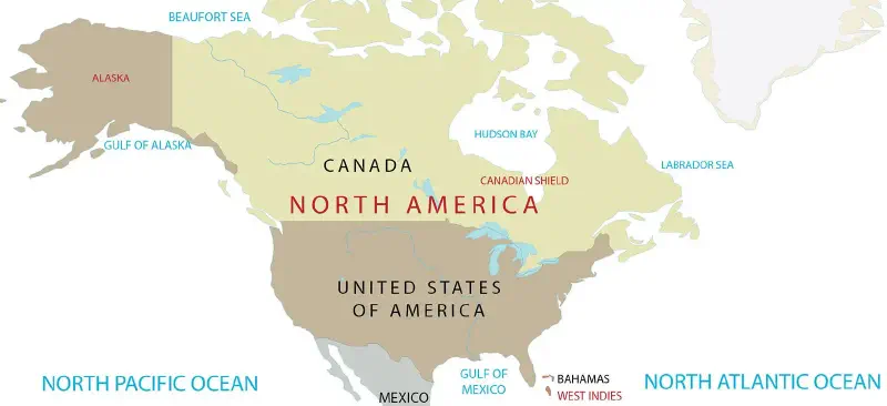
The United States occupies nearly an entire continent. Its interior is a vast, fertile, resource-rich expanse, crisscrossed by navigable rivers and protected by immense distances from any potential invader. But the key to its global dominance is not just its continental mass; it is its dual-ocean frontage. To the east, the Atlantic links it to Europe, Africa, and the Middle East. To the west, the Pacific opens a direct highway to Asia and Oceania. No hostile power controls a chokepoint between the U.S. and the rest of the world. The American navy can sail freely from New York to the Persian Gulf, from San Diego to the South China Sea, without ever asking permission.
This geographic hand of cards makes the United States almost impossible to invade. The two oceans are not just highways; they are moats. Any adversary contemplating an assault on the American homeland must first cross thousands of miles of open water, then land against a defended coastline, and then fight across a continent-sized interior with a hostile population and immense logistical challenges. No power in history has ever seriously attempted it, because the geography makes it a strategic absurdity.
But the U.S. is not merely defensible; it is supremely projectable. Because its coastlines are open to the oceans, it can deploy its military and economic power anywhere on the planet. The same ships that protect the homeland can enforce a blockade in the Persian Gulf or deliver humanitarian aid to a Pacific island. The United States inherited the maritime dominance of Britain, but with a continental land base that Britain never possessed. It is, in the truest sense, the perfect hybrid: the land empire and the sea empire combined into one, with no locked gates, no desert shipyards, and no foreign choke points barring its way to the world.
The Verdict of the Waves#
The long arc of history has a clear topographic pattern. Civilizations that are landlocked or restricted to enclosed seas can achieve great things—they can build magnificent cities, conquer vast territories, and dominate their neighbors for centuries. But they can never dominate the globe. The global hegemon, the power that sets the terms of trade and shapes the international order, has always been, since 1500, a state with unimpeded access to the open ocean.
Geography is not destiny in a crude, deterministic sense. Human choices, institutions, culture, and technological innovation all matter enormously. But geography is the initial condition that determines the options available to a state at its birth, and it is the boundary condition that limits how far those choices can take it. The Ottoman Empire did not fall because its people were less intelligent or its sultans less ambitious. It fell because it was a Mediterranean power in an Atlantic world. The Atlantic powers did not rise because they were inherently superior; they rose because their front doors happened to open onto the superhighway of global wealth, and no one could shut them.
The ocean is the ultimate force multiplier. It is the difference between a regional and a global power, between a sea and an empire, between survival and extinction on the grand stage of history. The Ottomans lost their land because they never had the ocean. The Atlantic states won the world because the ocean was theirs from the start. And the United States, cradled between two oceans, stands as the most powerful empire in human history—not because of any unique virtue, but because the map, in the end, is the foundation of all power.
Further Reading#
Prisoners of the Sea: Geography, Technology, and the Ottoman Collapse